INSPECTOR 5
Software
Inspector 5 and the Elios 3 work hand-in-hand in a seamless, and continuous workflow to provide operational continuity throughout the inspection process.

Understand where to focus your maintenance efforts
Without the right data management solution, acting on raw drone data can be a real challenge, leading to approximative reporting, uncertain decisions, and sub-optimal maintenance planning.
Inspector 5 and the Elios 3 work hand-in-hand, where flight data is organised by asset and can be instantly visualised in a digital twin of your asset—with no additional processing.
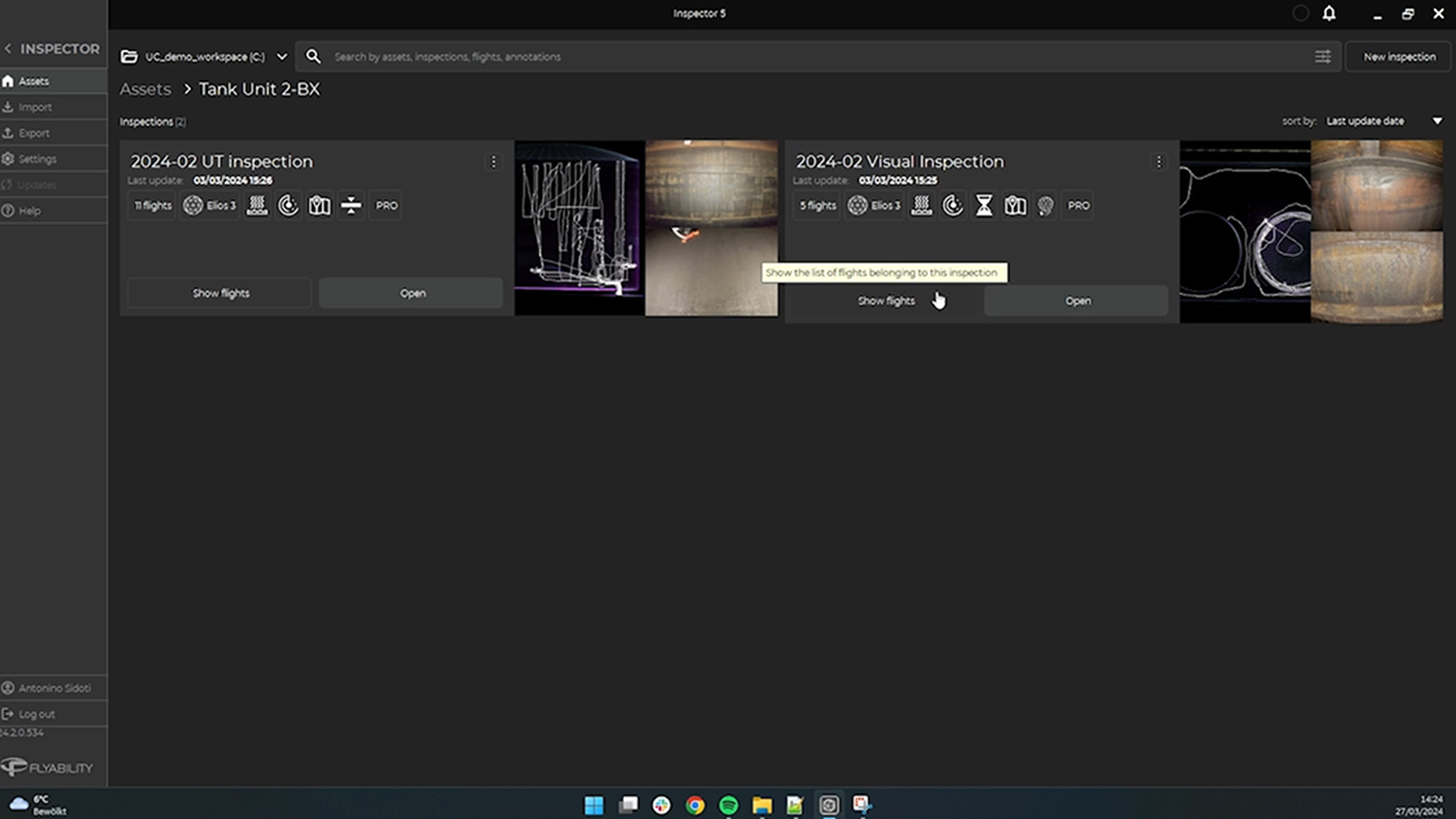
Organise data by assets and inspections
Inspector 5 comes with a fully re-designed user interface letting you organise your flight data by assets and inspections. With the introduction of workspaces, you can group multiple assets together by project, customers, plants, or any segmentation criteria you like.
This intuitive way of grouping flights allows you to easily navigate their inspection data ensuring intuitive accessibility as data enriches over time.
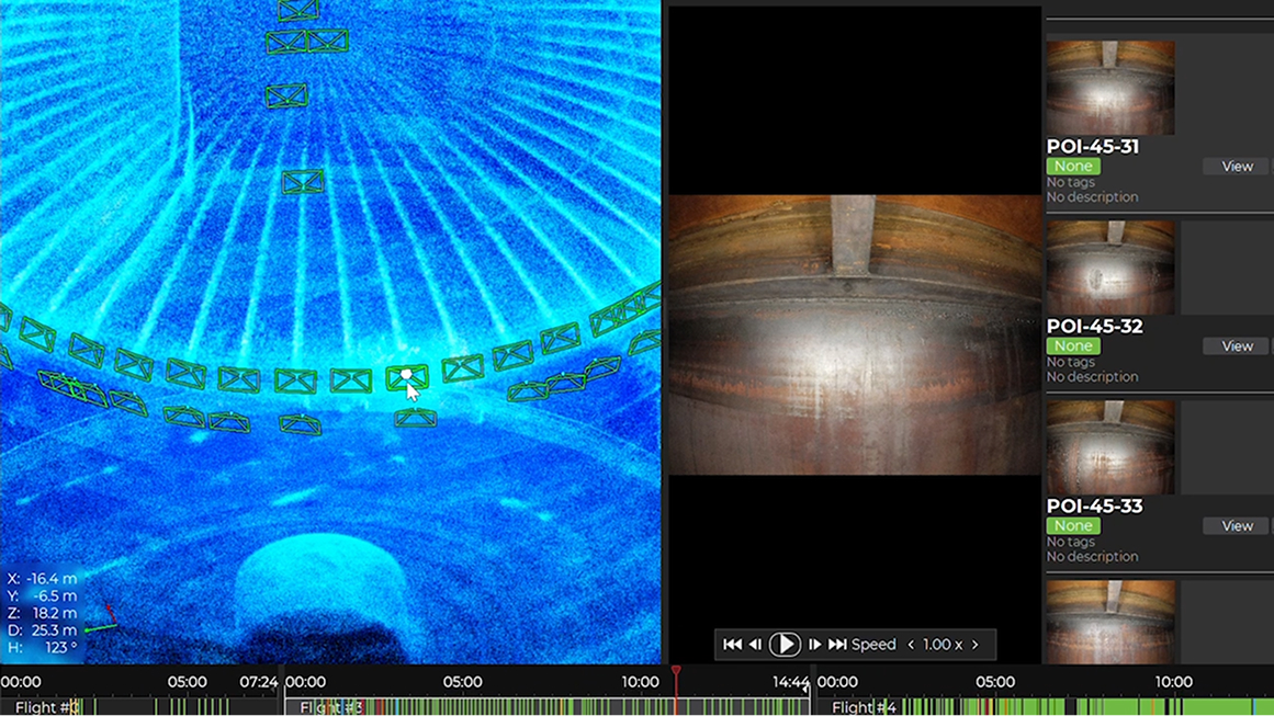
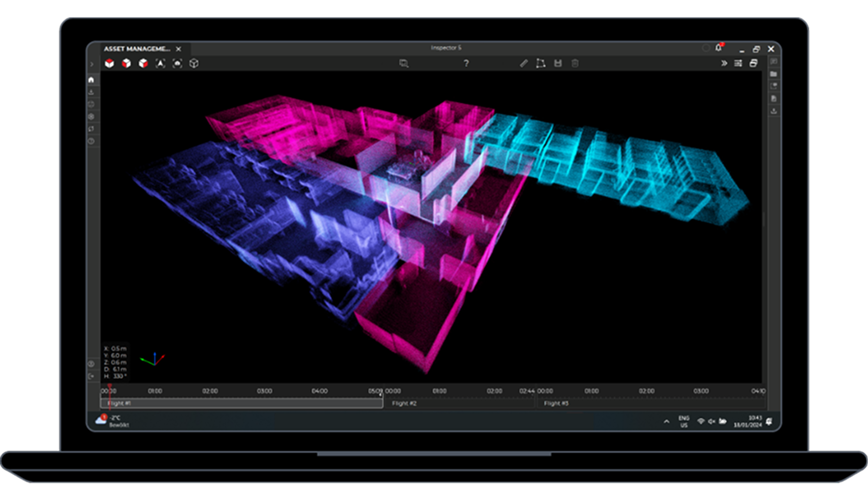
Localise defects on a digital twin of your asset
Visualise all data points from your flights in a high-resolution 3D map. Seamlessly navigate from one point to another by using the pan, rotate, and zoom functionalities.
Click on a point of interest to instantly access the corresponding video frame, allowing for precise correlation of inspection data with real-time visuals.
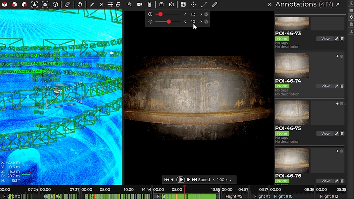
Precisely analyse defects
In the video player, screen through video frames to select the one that best shows your point of interest. Zoom in and adjust the lighting and contrast as needed to enhance the smallest visual details.
Utilise the Measurement tool to accurately size the defect.
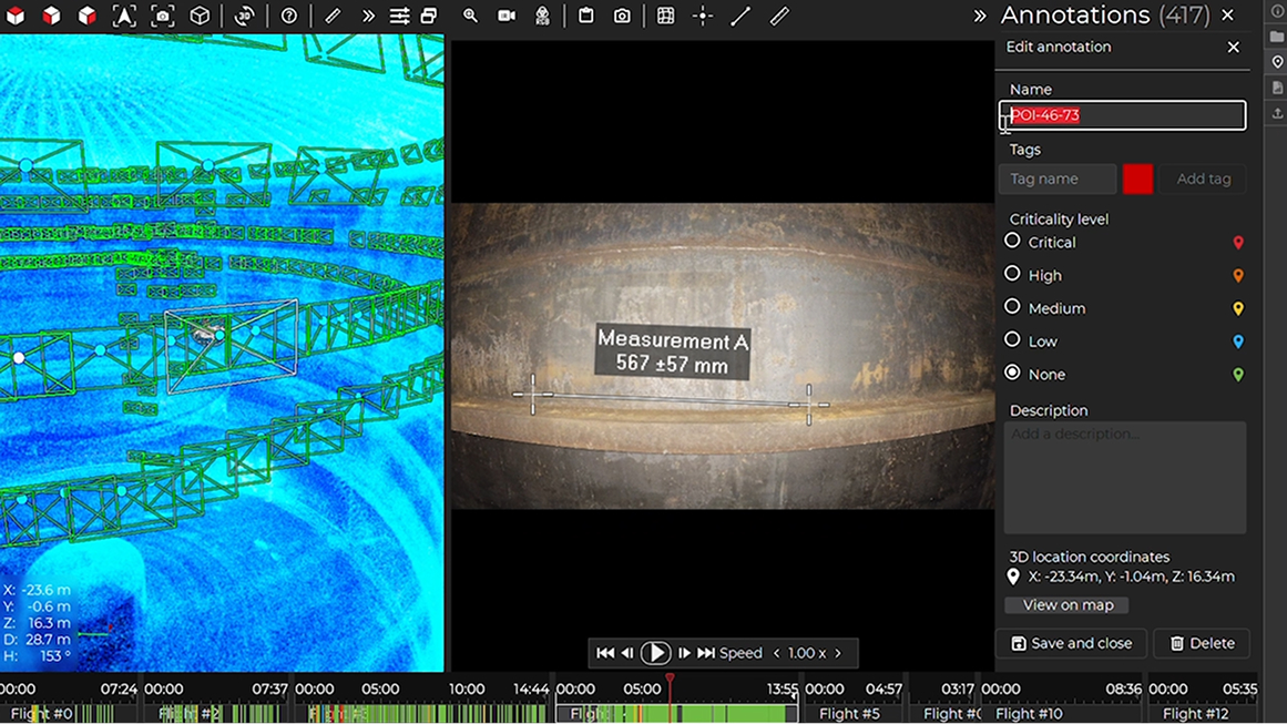
Document and organise your POIs
Streamline your documentation workflow by recording your findings directly in the video player. Give your point of interest a name and a description, classify them by criticality and organise them with custom tags.
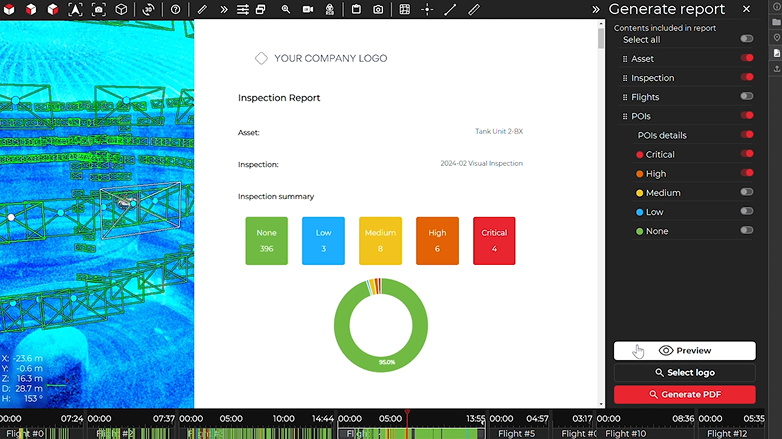
Share formatted reports
Compile your findings and insights into annotations. Filter and select the relevant information.
Add your logo and export your analysis into a neatly formatted PDF report facilitating sharing and distribution within your organisation or with your clients.
From flight-by-flight to inspection-wide reporting
Combined with the Asset Management software extension, Inspector 5 allows you to automatically merge all data from an inspection into a single frame of reference giving you a comprehensive view of your assets’ condition.
Q&A
Most drones commonly used outdoors rely on GPS signals for localisation and stability. However, they face challenges when operating indoors or in confined spaces due to the lack of GPS availability in these environments. In contrast, specialized drones like the Elios 3 are designed for GPS-denied environments, offering reliable localisation and stability without the need for GPS. These drones are specifically engineered to navigate in challenging conditions, such as dark, dusty, and confined spaces.
The Elios 3 is built for contact during flight, featuring a lightweight carbon-fiber cage that provides impact protection when the drone comes into contact with walls or structures. Additionally, the drone is equipped with bi-directional rotors, enabling it to autonomously flip back into an upright position mid-flight, even if it is toppled.
The Elios 3 is equipped with a 'Return-to-Signal' (RTS) safety feature that activates automatically if the connection with the remote control is lost. In RTS mode, the drone can autonomously retrace its flight path, returning to the takeoff point or continuing its flight until the connection with the remote control is restored.
The Elios 3 is equipped with an onboard LiDAR module that generates a real-time 3D map or model of the environment it is flying through. This enhances both the pilot’s situational and locational awareness while navigating the drone in confined spaces. The 3D map is also invaluable for identifying and localizing Points of Interest (POIs), such as defects detected during inspection flights. Additionally, the Elios 3 serves as a Scan-to-BIM tool, allowing the 3D model of the space to be used for creating BIM models and performing volumetric measurements.
The Elios 3 is designed with modular payload integration in mind. Currently, available optional payloads include the Radiation Detection Payload, UT Gauging Payload, Surveying Payload, and Flammable Gas Detector Payload. Additional payloads will be introduced progressively to expand its capabilities.
Request a Demo
Would love to see a demo? Share your contact details with us and our team will reach out to you shortly.